Wednesday 29 June 2011

29/06/11 - One Walk, Two Counties

Distance - 4 Miles Walking, 4 Miles on a train
Caches - 12
Train Fayre - £0
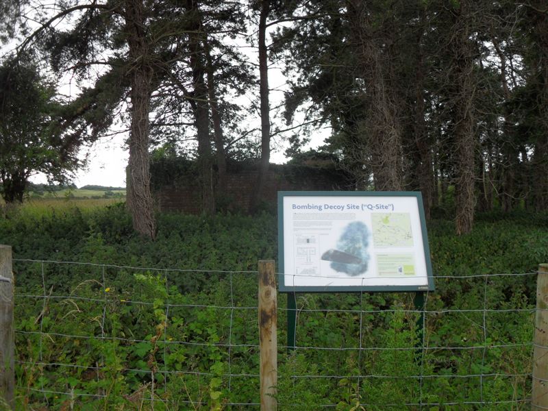
Interesting World War 2 Artifact - A Pill Box
Walk Inspiration

Goring to Pangbourne - Home by train


Down in the Reading Area.  I can either stay at a soulless Holiday Inn or look for something with a bit of atmosphere and culture.  Having walked from Reading to Pangbourne previously, I decide to extend my river Thames knowledge and add Pangbourne to Goring into my experience bank. 

When I stayed in Pangbourne last time, my hotel was hotter than the sun and next to railway line.  I decide to reverse the walk and stay in a different place, walking from Goring to Pangbourne this time. My hotel is the Miller of Mansfield.  Its a tradional English Pub.  Nicely decorated room that I know is meant for two people, as there are two fluffy bathrobes on the bed.  However, the toilet is in the corner of the room with no door.  Now I don't know about you but going away for a romantic weekend is not going to go down to well when you see you other half parking the breakfast, is it?

Turn you back love, I need to drop the kids off at the pool.
Incredible.  I can see my fellow american travellers choking on their bagels at this lack of human decency.

This minor discomfort (and I'm on my own, so as long as I dont catch myself in the mirror) is soon forgotton by the quality of the walk.

Goring is the winner of Village of the Year (south) in 2011. It is easy to see why.  Its also in Oxfordshire - and as Pangbourne is in Berkshire, this walk will take me into two counties.  I head down to the river and its beautiful.  First stop is the old wooden bridge and cache number 1.

Goring Bridge
I am heading downstream.  There is no end of great architecture and Paul Daniels has a house down here somewhere.  You'll like that, but not a lot.

This fella is so posh he has a detached dining room - in the sky.

But this fella cannot afford a Lawn Mower
From a navigational perspective, this walk could not be easier.  The vista opens up a bit and I can see where I could have walked, the Chiltern Hills.  When I come back here again (alone, as there are some things a wife shouldn't see), I will head out onto these hills.

Next time I'm in Goring, I'm up there.
There are caches every 500 yards.... Including one at the railway bridge which will bring me home tonight.

Taxi for Mappiman

The walk continues and I hadn't paid too much attention to the route but it does eventually go inland (althought still on the Thames Path) up a decent climb with woods between me and the water.  Its here that I discover another WW2 artifact.  Its funny how there is continuity on these walks..... on the weekend it was a false airfield, today its a pill box.  I do think however, if the Hun had made it this far up the Thames, taking London, the war would have been over.  British fortitude at its best.

Who do you think you are kidding Mr Hitler?

After another stiff climb, its a tarmac road all the way down to Whitchurch on Thames.  I am instantly greeted by the Greyhound.  I was tempted to eat here, but as I was the only punter, I went for a packet of bacon fries in their garden.  The starter of the gods.

I bloody love walking

I didn't have to wait long for my tea.  Out the door of here, and down the road and there is the Ferryman.  This is positively heaving with people and I pop in, peruse the menu and convince mein host to replace the pepper sauce on the steak with a couple of fried eggs. Which he does at no extra cost.

Now, all that remains is to get the train back to Goring.  This involves crossing the river and into Berkshire - over a bono fido toll bridge but free to foot passengers and then dealing with British Rail.

Pangbourne Toll Bridge

This sign could save a brummies life on Stourport's Bridge in the Summer.  Then again, its probaly better where it is.
Follow the road back to the Station.  Next Challenge.  The ticket office is closed.  The automated ticket machines are all broken.  The platform indicators aren't working.  I use the information machine on the platform - thankfully, the station is empty - and I swear I am routed to India.  "Which Station are you calling from?" - I reply "Pangbourne".  Explain my position and she says "Oh just get on the train from platform 2 - if the ticket man comes, just pay him". 

He didn't come, so I hit the pubs of Goring smug in the knowledge that I got something for nothing.  This is extended to free wireless in the hotel so I can blog my walk. 

Life is all good - free eggs, free train travel, free wireless broadband, free access to the throne - unencumbered by such social niceties as privacy.

Saturday 25 June 2011

25/6/11 - Caching in the Nether Regions

Distance - 4.7 miles
Caches - 13, 1 DNF
First Cache
Interesting World War 2 Building - A false airfield

Netherton, Worcs


I have the house to myself this morning.  Alex is at a sleep over.  Ellie is still going to work.  And today, so is Sonia.

So how will I entertain myself.  I could make a full english breakfast and watch the rest of Spiral.  I could dress up in Sonia's lingerie and dance to Madonna in the living room.  As there are no sausages and its too much of a squeeze, I decide to stick with geocaching.  Although I do throw a few shapes whilst convincing the dog this is a good idea before leaving.

Pershore is a goldmine for caching - there always seems to be new trails popping up and this one, around Netherton, is by the same person that put together the Peopleton one completed last week.

It really is a straightforward route - taking in green lanes in an almost complete rectangle.  There isn't a great deal to look at - apart from the magnificant Bredon Hill on the soutbound stretch.  I prefer this hill to the Malverns, as you get a great view across to the Malverns from here.

This is all on the flat.  The dog looks typically bored, as I keep looing for the boxes.  Today, I attempt as many as possible without the clues for a bit of variety.

Not enough for a swim at "Bridge the Gap" cache

First views of Bredon Hill.... Molly can't take her eyes of them

On reaching Netherton farm, we head along a bit to find the route back.  The one cache that I could not find (and there is always one) is on a building.  This has an info board and it was a WWII decoy bunker to confuse the Germans into thinking it was Pershore Airfield nearby.  Pershore was bombed twice and this once, so it added some value.   Had a good look around, but no joy.  You can enter the bunker and I did, for that authentic Blair Witch feeling.  I think the horse in the field was laughing at my fruitless search.

Confusing Jerry
Back up Smokey Lane to the car.  Thanks again to jayvon for helping me achieve my 100 caches in a calendar month.  I am about three off and have a trip to Goring, Berkshire in the week which looks like cache heaven.

On the way back, I go through Pershore town and there are a group of Morris Dancers performing.... now there is an idea for a hobby and my Madonna moves may not have been in vain.

Wednesday 22 June 2011

22/6/11 - Manchester, so much to answer for

Distance - 7 Miles
Walk from - Walkingworld
Geocaches - 5
Famous person without socks - Rio Ferdinand
Breweries - 1

Manchester Architecture


Ellie has an open day in Manchester University today - so a day off work, a 7:30am start and a drive up the M6 with her mother and Ellie's friend so that they can go and learn all about student life (paying for chips by cheque) and I can get re-acquainted with a city that I used to know well.

Park up close to the Uni and walk with them up Oxford Road to drop then off.  I now have 4 hours and an excellent guide from walking world to take in most of the architectural highlights of the city.

First stop is the Sackville Gardens for a cache next to Alan Turing.

Caching doesn't have to be lonely

Sackville Gardens brings me out into Canal Street.  This is the gay area of Manchester and the road sign frequently lost its C.  Before 24 hour drinking, it used to be the only place you could get a late drink, so all roads used to lead here.  The last time I was in the new union, one of my team goosed an older homophobic team member who turned around and offered him a fight in a victorian boxer style.  It remains one of the funiest things i have ever seen.

Walk leads onto Portland Street.  There is a collection of three oldy worldy pubs that I am pleased are still here and haven't been taken away through progress.  In 2002, I was a frequent guest at the Thistle Hotel.  As I was uncultured in those days, we mainly went to city bars (and drops head in shame, Jumping Jacks).  However, I have fond memories of the landlady at the Grey Horse Inn who used to abuse us on every visit.  We took it as Northern Hospitality.

Head on up and then cut through Picadilly Gardens for a muggle central cache, which I soon find.  Avoid doing an Alan Bradley and head down Mosley Street.  In 2008, I met a manchunian native who tried to take me to Mr Thomas Chop House.  He got lost and this meant lots of walking around this area and all its alleys.

Get a bonus on the walk - a new greggs is opening and they are giving out free coffee...  This lasts me past the central library, midland hotel (where I stayed once) and onto the G-Mex.

Let me take you back to 21.07.90.  To get over the GazzaGate, Sonia, Danny, Jane and myself went here to see the mighty Inspiral Carpets at the peak of their organ based, strange haired fame.  Sonia and Jane were left in the seats whilst Danny and myself went down into the mosh pit.  The subsequent shuffly dancing that I performed kept Danny amused for the next 20 years.

Home of shuffly dancing
From the GMex, I pick up the canal.  Used to drink at Dukes 92 in the summer and at last, almost 25 years after I should have gone there, I have managed to find the Hacienda.  Its now been demolished and is a car park, but if you look carefully, you can see the quotes about the place in the building.

I merely read about it... 

Brought back the memories of New Order, Happy Mondays, God's Cop, the exotic sounding gun battles.... my own clubbing experiences revolved around talking Malcolm into letting me into the Severns Club, when I wasn't a member.

The canal is a hidden world within the City.  Soon comes out at Deansgate Locks.  Most of the clubs have now changed names, but there was a night in 2002, when I was in far end bar and Kylie was in the Sugar Lounge at the opposite end.  My chance to talk her into coming geocaching with me and I blew it.

The bar where I met an Antipodean Sex Midget (Almost)

Follow the canal down, under the railway and tram lines and then back up to Castlefield.  In 1998, I presented at Granada Studios and in 2003, I used to eat at the Ox - which at the time was Manchester's top gastropub - if such things existed then.  Today, its 11:45am and the chipper is open.  Go in and after a taxi driver orders a "Chip Barm Cake", I consider copying his order, but err on the side of caution.  £1.50 for a chip bap.... should have gone for it.

Liverpool street bring me back to Deansgate and I see exactly where the tallest building in Manchester (Beetham Tower) is loacted.  This is new to me.

One Day, I will stop at the Hilton
Used to install the world's most complicated printers for Abbey National along here in 1997.  Its the main shopping area, so I take detours up the side streets to see the posh shops, eventually winding up by the cathedral for another cache.  This is where I bump into Rio Ferdinand.  Its quite interesting really, he is sat outside the shops with his partner and presumably child.  Soon, people spot who he is and once the first person asks for an autograrph, a queue of peope all start waiting for photos etc.  He must like the fame, otherwise he would have been more inconspicous and wore socks.  I was more interested in successfully getting my cache.

Stop for a drink at the Old Wellington.  This is Manchesters oldest building and has quite a history - moved 300 yards, damaged by the IRA bomb etc.  Its also a great place to sit and read in the sunshine.

I am actually a lot happier than I look
Up past the Print Works.  2003, we take Alex to his first horror film here.  He didn't like it much and screamed most of the way through.  Then again, Scooby doo was particulary terrifying.
I now go off piste and look for the Marble Arch up on the Rochdale Road.  This a pub that comes with a reputation, with its own micro brewery on the back.  Lovely place in the middle of nowhere - the beer was great and tasted a lot like boddingtons to me.

Getting near the end of the scheduled walk now - and after picking up the canal again, I am back to Picadilly and pass the Place for Living.  This remains my favourite hotel in the land and I used to love coming here on a Monday night during 2002.  I notice that my chinese takeway - which was a run down, free standing building has been replaced with a shiny new glass and chrome place.

All that remains now is to return to the University.  I need to work on Ellie so that she makes this place her choice, so that I have the excuse to come here more often.

A fantastic trip down memory lane for me.

Sunday 19 June 2011

19/6/11 - Not one place pronounceable in the West Brecons

Distance - 12 miles
From - Spring 2011 Trail Magazine
Confusion - Where to Park
Geocaches - 2

Picws Du


Reading through Spring Edition of Trail magazine and I realised that the Western side of the Brecons has been neglected.  This has more to do with the distance involved, rather than whether the mountains are any good or not.  Set the alarm for 6am and was out for 6:40am, with everything important apart from a mobile phone.  The journey at this time of day is a pleasure - Brecon in 75 mins and then another 40 down the most bizarre roads known to man - even going through a farmyard at one point.  There is no way this would be possible in Winter.

Sat Nav - are you sure its this way?

Arrive at Llanddeusant.  The magazine article provides the grid ref for the start of walk and a picture of a nice area for parking.  The two things are unrelated.  I drive around for a while looking for somewhere reasonable to park and end up popping into the the YHA (co-ords for walk start) and the nice man allows me to park there.  Why you would show a picture of a nice car park 1.5 miles away from the walk start is beyond me - unless they want to hoodwink inexperienced midlanders into making the journey.

Worried about the start of the walk for two reasons.  1)  I am going downhill, which means the last leg will be uphill and 2) The weather doesn't look the best.

My head will soon be in those clouds.

At the end of the road, turn right onto what has to be the most poorly signposted long distance path in the world.  The brecons way.  The way back takes in a decent stretch of this and not only is it not on the OS map, there isnt a single waymarker on the ground either.  The way is clear enough when you are there though.

Start the stiff climb up grassy banks to the starts of the unpronounceables - Bannau Sir Gaer to Waun-Lefrith.  You know what, I am sick of this.  Lets just call them hill one, hill two and look at the pictures.

We are on a ridge path that circumvents Llyn y Fan Fach (can't help myself, lake 1).  Impressive views, as once up, its a clear drop down and we just skirt the edges for some great photo opps.

What views.
no sarnies - just a cache at Hill 1

I love it once you have gained the height.  I have good views, but the light isn't great for the photos.  Still, you cannot have everything in life can you.  Work my way around the edge, meeting the first groups of walkers of the day, both pairs coming from the opposite direction.  What do they know that I don't?  Work my way around to Fan Foel, my favourite, as I can spell it and it has a shelted and a Trig Point.  I can eat my malt loaf in comfort.

Trigger

Then have a bit of ticklisting to go up and straight back down Fan Hir.  This isn't required for the walk, as we retrace our steps to drop down a staircase to Lake 2. 

This makes the walk - we see the lakes from the high ground and then drop down and see the high ground from the lakes.  A unique experience for me.

Simple walking now, although I do see 2 elderly gentlemen, who either still love mountain walking or have been on this route for a considerable time.  Walk with them a while, overtaking as they stop for sandwiches and then them catching me up as I finish off whatever else I can find in my sandwich box.

Mappiman at Lake 1
Then its a simple case of taking the access road down running parallel to the run off from the damned lake.  Not sure how it all works, but its pretty and I am sure there are fish leaping out of the pools at the bottom.

Lake 1 Spill Off
Past the car park (!) and then the mile uphill on the access road back to the hamlet that begins with two ls.  I have noticed on the map that there is an intriguing entry called the "Red Lion".  Could this be a pub to offer refreshment to a weary walker?

No, its the Youth Hostel.
Summary of things I have learned...

1) YHA people are lovely, even if they don't sell beer.
2) Trust your sat nav
3) Cause asking for direction is futile.
4) All walks should take you to a mountain ridge and then bring you back along the bottom.

Friday 17 June 2011

16/6/11 - Capital Ring Phase 4

Start - Crystal Palace
End - Streatham Common
Distance - 4 Miles
Interesting thing - Nothing
Previous Stages - Stage 1, Stage 2, Stage 3

Capital Ring Phase 4


Not sure what will be the best part of this 15 stage journey, but I am fairly sure that this leg will represent the worst stage.

Leave Victoria and arrive at Crystal Palace.  Follow the green signs and it doesn't take me up to the town where there were some expansive views but dips into a housing estate and circumvents and area of interest.  Go through Norwood and a couple of recreation grounds.  Spot an 8 year old labradoodle and talk to the owner about whether her dog is a) lazy or b) hates her.  It would seem that my labradoodle is unique.

There's really not a lot to commend this stretch of the walk.  Norwood House is the architectual highlight.

Norwood House

Soon arrive at Streatham.  There is a collection of eateries and pubs in the area.  Now I know that Mick Jagger has a house in St Lucia, but I cannot believe that he goes to Bandit Country for his pizzas.

He got Sticky Fingers
Instead of this dubious claim to fame, I went to the Greyhound Pub over the road.  It was empty, apart from a sinister pole and a friendly bar man who I think had been watching a lot of Westerns as he asked me if "I was passing through".  We then got onto the subject of what refreshment to have and this is one of only 300 pubs to have Stella Black in a new ceremonial glass.   Well I had to have something to remember the walk by.

I admit, I thought long and hard about Half Inching it.

Timed it just right for the train back from Stretham Common into Victoria.

Lets hope the next stage is more exciting.

Monday 13 June 2011

13/6/11 - Power to the Peopleton

Distance - 3.5 Miles
Number of Caches - 11
Previous Peopleton Round

Peopleton Geocaching


A Geocacher Lives Here
Back in October 2010, a new round appeared in this delightful Worcestershire Village.  This was completed on the first weekend of publication, hiding from the other teams of geocachers that had the same idea.

I should have waited until a Summer's Monday night - as I had the place to myself.  The original trail has now been disabled and a new one has been laid that takes in many of the same paths.

Take in the last parking space in the pub and head up past the church.  I rememeber these paths and I remember the cache that looked as though it was in someone's garden and they were gardening at the time.  This round sees an igenious one on the bridge, a but further away from prying eyes.

The Dog's got a sniff of the cache.... Good Dog

Last time I was around Wolverton Hall, I was hiding from Wrighty.  Today, I am dodging a fella with a tractor mower.  Manage to take the wrong paths but end up taking a small diversion back to one buried by bricks.

We then follow permissive paths with great views across Malvern and then as I turn the corner, Bredon Hill.

At Aston Hall Farm we have a brush with nature, as we cross a field of young bulls.  This is the second time in three days I have been the victim of a bovine charge.  To make matters worse today, the bloody horses join in.  I don't mind cows, as they are all mouth and no trousers - a quick "Get out of it" sends them running.  Horses, however, are farmyard enforcers and that just makes them more angry.  Manage to get the dog through the gate and take a photo for evidence.

Wanted!  Inciting a farmyard riot.
Then we are on green lanes that get increasingly puddle bound from the rain yesterday.  Blog Fans will notice that my daughter was 17 yesterday, so I have bought an example of a road sign to test her.

Top Sign means "No Access in Mom's Focus"

I have previously commented on what a beautful spot Barrel Bridge is.  Today, the ford is up because of the rain.  But by how much?  They is only one way to find out - chuck a Ribena bottle into the flow.

Shoulder High to a Labradoodle

This green lane brings us out onto the road, just north of Peopleton and a nice walk through the village reveals all of its architectual glory.  Lovely place.

As the previous cache trail had a bonus in the pub car park and this one starts just over the road, I have come to the conclusion that jayvon is the landlord of the Crown.  Thanks for another great trail.

Saturday 11 June 2011

11/6/11 - I bored a dog and I liked it

Location - Marshbrook
Distance - 4 Miles
Number of Caches - 19 and a Bonus.
Thing on my mind - How did I end up with a 17 year old daughter?
Happy Birthday Ellie!

Marshbrook Geocaching


Thinking of places to go today and thought its been an awful long time since I have been up Long Mynd.  There is a 10 mile route from CW magazine that I have had my eye on but when I looked at likely caches, there is an extended round from Marshbrook.

I decided that these could not be ignored.  Get up early and the dog does he now usual performance of hiding and then shaking at the top of the stairs when she sees my new walking hat on my head.  She's not overwalked, but I think over-cached.

Fortunately, even though I wasn't on the high ground of Long Mynd, I still got the views.  I was thinking of extending the walk to go up onto the Portway and get a bit of wild walking in, but the weather looked omnious after a terrific start.  Plus, taking in the caches adds time to a walk and these caches came thick and fast.

Long Mynd and Ragleth Hill
Park up at the bike shop at Marshbrook.  Nice of them to allow geocachers use of their facilities.  Head up on a short climb through fields of sheep, finding easy caches every few hundred yards.  It looks like this was a cache series with clues for a bonus, which was then extended to include additional caches.  As a result, I occasionally forget to get the clues and end up with around 90% of the digits required.  Don't bother looking for the bonus, but I think I was able to plot where it was likely to be.

Through the farm at Whittingslow and the trail gets you to go along a rather too busy road to catch a couple.  Not the easiest, searching on the side of a road with a dog on the lead.

Soon back on a green lane with only the sheep for company.  Apart from motorists, I don't see a soul on this walk.  At Manor Farm, I head down a much quiter road for 3/4 mile to return to the bike shop.  On the way, there is a cache in the hedge and the dog gets that bored with all the stopping that she lies down in the road in despair.


So bored of caching - I'm going to lie down here and hope a truck comes
 There you go.  I have managed to bore a labradoodle.


Views all along the walk were excellent and there is not much climbing to be done.  Dog needs to stay on lead because of the traffic and sheep - so I don't think she liked it so much.

No caching tomorrow - Ellie's birthday.  The dog will be pleased - not least cause she loves birthday cake.

Sunday 5 June 2011

5/6/11 - Chelmarsh Resevoir

Distance -
Number of Caches - 18 (Walked past one, so only found 17)
First Cache

Chelmarsh Resevoir Geotrail


After a great week of walking and caching, I am back in the rural midlands.  How do I know this?  When I drive through Kinlet, there is a sign advertising the annual Pig Race.

I've decided that I am going to aim for 100 caches in the a calendar month.  Should be easy, but not yet achieved.  There is a new trail of 18 at Chelmarsh, so after dropping Ellie off at work, I head out there through the intermittent rain.

Park up in the side road next to the pub and head down to cache number 1.  Thought it unlikely to have the trail to myself and on approching GZ, there is a bizarre noise and I head around the corner and there is a lady with a map and a man in the undergrowth.  This can only mean one thing!  Say hello and decide that rather than follow them around, I will do the route in reverse.

This meant retracing steps and taking a green lane that is so straight it can have only been built by the romans.  There are a number down here, including a a detour across knee length wet grass to pick up one. 

First 6 of the day finishing up at the now closed Kings Arms.  Is there a sadder sight in the world than a closed down, boarded up pub?  Even at 10am on a Sunday?

Miss out on one by not looking at the map properly (they are coming thick and fast)  - but I do return to this in the car to keep the numbers up.  I am now at the resevoir for the first and will be making a complete loop of it, picking up the Jack Myton Way.

Chelmarsh Resevoir
Bump into the other cachers around cache 9.... exactly half way around the route.  As I can see their completed logs, I know now these to be Shortmat, who I have seen on a number of other logs.  Miss out on one, where I was concentrating on finding the footpath - could go back, but decide this will be my one to stop a 100% round.  There is always one.  Work my way around with the caches getting increasingly easier, until I get to number 1 - which takes me an age to locate but my patience is rewarded.

Thanks to spekey for laying and maintaining the trail.  Suited my needs for a damp, overcast Sunday.

Back to the real world tomorrow. 

Friday 3 June 2011

3/6/11 - High Drama at Coverack

Miles - 3
Geocaches - 3
Best Pint - Paris Hotel
Exciting Event - Air Ambulance

I got my big lie in for the lads.  The art of travel is to be anywhere but where you are today.  This doesn't apply when you find somewhere as beautiful as Coverack.  This is perhaps the nicest place we have been in England.  Honesty parking for a short walk down to a beautiful dog friendly beach...  lots of shops and a nice town, with the Paris Hotel on the headland.  It might have been the walk, but I think they served the best Tribute ever.

Yesterdays update....  Walk with Sonia at Helford, then meet Family Rocket at Kynance Cove.  The tide is out, so we get to do the Asparagus Island geocache.  Nice bit of adventorous climbing.  Home for hot tub, then the best Fish and Chips ever at the Lizard and a couple of pints at the Witchball.  I am not sure that I have ever had a better day.

After getting the family settled on the beach at Coverack, its too hot for me to sit around, so I head off north up the headland through Lowlands to pick up three caches.  Cache 1 I have to get on the return, cache 2 has a family of cachers already there, so I have to lurk around and cache 3 is at the site of a wrecked boat.  The walk would have been part of my St Keverne walk, if I could have fit it in.

Dog Friendly

Now, I am tired
Return from the walk and need a pint, so we head up to the Paris Hotel on the headland.  Officially the best pint of Tribute in Cornwall.

Look out Ladies of Cornwall
Cheers!  Here's to my greatest holiday.
And the drama - on the exit from Coverack we are 2nd on the scene to a lady cyclist in the middle of the road.  She is conscious but does not want to be moved and does not know what happened to her.  Cue Ambulance, Police and the Air Ambulance.  Very exciting to see the helicopter land.  Sure the lady was fine and who knows what cause her predicament.  Possibly heat stroke.  Sonia felt that they should have moved her to the side of the road earlier.  She is not known for her patience.

So that's it for cornwall.  Next blog, a five miler around Tipton.

Thursday 2 June 2011

2/6/11 - Where the River Meets the Sea

Distance - 5 Miles
Number of Caches - 0
Interesting feature - A way up one river and back down another

Helford River


Ok, you can have too much of a good thing. This is walk number five and I am absolutely knackered. I am meant to be on my holidays!

Yesterday's news - Solo Walk, FEB, then over to family rocket where we went down to the sea but it was too cold, so we came back to there campsite for an epic game of football. The game was complete with another sibling pair of Ellie and Alex. Then leave at 8pm and the car had a row with ditch, which nearly involved a tractor to extract it. Hopefully no damage done and it will get us back home, as the RAC may not be able to cope with four people a dog and all our luggage.

Woke early today and can't even blame the seagulls. Thought I would be on my own, but both Sonia and the dog were expressing an interest, so we had a rediculous drive to Helford River where I thought I might lose the car to another ditch. My audi was designed for the autobahn.

The walk is a little different, but still on the SWC path. We are walking up the shaded woodland alongside the River Helford to St Anthony. Nice walking and there are plenty of coves for Molly to have a swim.

Helford River

Cove
Submarinedoodle

Climb up to St Anthony.  Here, we have the Helford to the left, the sea in front and the Gillan Creek to the left.  Nice spot for views.

Water, Water, Everywhere

Dropping down to Gillan Creek
The footpath takes us back to Manaccan and then through lovely woodland back to the car.  This is how early we are up.... the cafe isn't open for breakfast.  The Cornish wit has been entaining Alex all week, but I must admit I prefer my humour a touch more subtle.


After 17 Assing places, a variation - complete with a Johnston at the top


So, after five pre-6am starts and decent length walks... stunning views and some good geocaches, I am going to probably call it a day.  Tonight, I am going to hit the pub.

Wednesday 1 June 2011

1/6/11 - Walking the Lizard (The dog wouldn't get out of bed)

Distance - 8 Miles
Caches - 12, I think
Company - Rabbits, magpies and seagulls
Interesting Geological Feature - A Zawn

The Lizard


Here is our cottage from the front....

Well, the annex at the back.
Yesterday's holiday update - morning walk with Sonia.  Then an afternoon in Helston.  A visit to Cornwall's oldest brewery, where the make Spingo beer.  Have 6 pints and you can shout Spouse.  Then home for curry tea and take the whole family for a 3 mile round trip to Kynance Cove so the dog can have a swim.  The cottage now has a perculiar smell of Indian and wet dog, not totally dissimilar to the Indian at home where that person found a dog chip in their meal.

So today's walk.  We were awaken at 5:30am by some seagulls doing the river dance on top of our roof.  I knew I had the big walk ready for today, so I took it as a sign to get up and head out.

The geodog, never even moved.  I think we have done her in.  So this morning, I went out alone.  A solo rambler against the elements with a fistful of caches to find.

I don't think this walk is going to be topped this year.  Take the short route to the coastal path and I am doing the west coast of the Lizard, cross inland, then the east coast and back along the bottom.  The photos will really tell the story.

Around to that headland to cut in
Find the first three or so caches that are part of the Lizard series.  The great thing about this time of the morning is that no-one is around to spot my searching.  My only DNF is part of the Nice Places series, where the clue of under a rock didn't help when there were hundreds of rocks.
Cache under here... nice clamber down.
Come, once again, to Kynance Cove.  This is the 3rd time and still the tide is in, so I cannot get to Asparagus Island.  Oh well - there are two days left.

Came from the distant headland.
I am now walking inland for a good three miles across Lizard Downs to pick up the East Coast of the penisula.  There is one cache at a church and then I come to the Devil's Frying Pan.
If he has sausages on, he can have my soul

The Frying Pan - A Zawn
A Zawn is a collapsed sea cliff.  I am getting to the point that there might be a collapsed geocacher to go with it.

Thats not even my headland...
This is uncharted territory for me and i cannot even see the lighthouse that I know is on my headland.  There are no end of photo opportunities to go with the cache trail around here... so I'll pick out the best.

Sea Arch

Lifeboat station reconstuction in distance

I came from that headland

41 and beat the camera 10 second auto photo

Another cache location and I can see my house
A stunning walk.  Get home and I am locked out.  Consider the hot tub in the nip but think better of it.  Sonia and the kids are soon back and aren't I lucky, they have the ingredients for my FEB.

And to answer the mystery of how I am managing to blog when I cannot get a phone signal.